
The view from Hurlbert’s Hill is amazing!!
Bartholomew’s Cobble is named for its two rocky knolls—or “cobbles”—rising above the Housatonic River. Hurlburt’s Hill, the property’s highest point, rises 1,000 feet to a 20-acre upland field on the Massachusetts-Connecticut border that offers panoramic views northward up the Housatonic River Valley. Boasting an enormous variety of woodland flowers and fern species, the Cobble’s amazingly diverse flora earned it a National Natural Landmark designation in 1971.

Lime Kiln Farm has been known to host more than 500 species of plants including many rare varieties. A key tract of land within the 14,000-acre Schenob Brook Area of Critical Environmental Concern, the rolling hayfields, limestone ridge, conifer forest, and former pastures attract more than 50 species of butterflies as well as Pileated Woodpeckers, Alder Flycatchers, and Red Foxes. Check out the Mass Audubon Page Here
About Lime Kiln Farm
Lime Kiln Farm has been known to host more than 500 species of plants including many rare varieties.A key tract of land within the 14,000-acre Schenob Brook Area of Critical Environmental Concern, the rolling hayfields, limestone ridge, conifer forest, and former pastures attract more than 50 species of butterflies as well as Pileated Woodpeckers, Alder Flycatchers, and Red Foxes.
Acres 363
Trail Mileage 2 miles
Trail details >
Sanctuary Highlights
The circa-1909 40-foot-tall kiln; limestone was once quarried there and turned into lime.. Stonewalls and wire fences that attest to the property’s long agricultural history. Green Frogs and bullfrogs in the small farm pond during the summer. A magnificent view of Mount Everett from the walking trails. Programs offered through Pleasant Valley Wildlife Sanctuary.
Location Silver Street, Sheffield, MA
Get directions or contact us >
Hours Trails: Open daily, dawn to dusk

Drury Preserve – The Nature Conservancy – Sheffield, MA
This preserve is home to great blue herons, bobcats, and a variety of forest and plant communities. There is a spectacular view across Schenob Brook of Mount Race. The preserve includes the Drury tract (65 acres), and also encompasses more than 300 acres of contiguous, protected land.
A lightly marked trail, which is approximately a 3-mile walk, gently slopes through a variety of wet and dry communities. There are boardwalks over the wettest areas, but waterproof shoes are a good idea.
Directions from Route 90W (Mass Turnpike) to Exit 2 (Lee).
•Follow Route 102W to Route 7S (Sheffield center).
•After the small shopping plaza, take the first right onto Berkshire School Rd.
•Take the second left (Salisbury Rd.) and then another left (Barnum St.).
•The preserve is 1.2 miles down Barnum Street with a small clearing to park on the right. There is no sign.
•Walk into woods at right and look for trail sign about 100 ft. in.
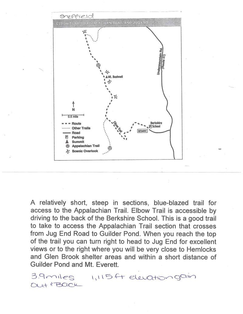
A relatively short, steep in sections, blue-blazed trail for access to the Appalachian Trail. Elbow Trail is accessible by driving to the back of the Berkshire School. This is a good trail to take to access the Appalachian Trail section that crosses from Jug End Road to Guilder Pond. When you reach the top of the trail you can turn right to head to Jug End for excellent views or to the right where you will be very close to Hemlocks and Glen Brook shelter areas and within a short distance of Guilder Pond and Mt. Everett.


Sheffield Lime Kiln
The Sheffield Lime Kiln established 1909, part of the Lime [...]

Hurlburt’s Hill in Sheffield
Bartholomew's Cobble in Sheffield, Hurlburt's Hill is just a few [...]

Bartholomew’s Cobble in Sheffield
Bartholomew's Cobble in Sheffield, Managed by The Trustees of Reservations, [...]

Race Brook Falls and Mount Race
Race Brook Falls and Mount Race Sheffield, one of our [...]

Sheffield Appalachian Trail Shays Rebellion
Shays's Rebellion trailside, Sheffield.The Revolution may have been won in [...]

Sheffield Three Mile Pond
Keeping cool Saturday after hiking in Ice Gulch in Great [...]
