
April 27th was not a Spring-like day! Western Mass Hilltown Hikers and Hilltown Land Trust both hosted this hike. Despite gusty winds, cold temperatures and snow a great group turned out to hike Round Top Hill in Chester. This hill is seen from pretty much any where in Western Mass because it is the highest peak in Hampden County at 1,765 feet elevation. It is also part of the recent land conservation donated by Will and Sarah Freedburg to Hilltown Land Trust and is adjacent to both DCR Chester Blandford State Forest and the JJ Kelly Wildlife Management Area. The Round Hill Trail consists of a portion of the Unkamit’s Path, the white dot blazed trail that runs East to West from Westfield to Lee and meets up with the Appalachian Trail there. The 400 feet of elevation gain is completed within 20 minutes, natural rock foot steps all the way to the summit of high elevation forest with a grassy field filled with shag bark trees. The spring wild flowers on the mountain are plentiful and are in bloom at this time of year. The last two days of heavy rain made the hike a mud filled event that was well worth the stunning 360 degree views at the summit. The Fire Road trail is much less intense going down with views until we returned back to Round Hill Road. I highly recommend this hike in the Spring, Summer and Fall. Two hours is the total loop time including taking pictures!
On March 30th we explored deeper into Chester Blandford State Forest. Starting at the Sanderson Brook Falls parking lot on Route 20 in Chester in moderate fog we hiked up Sanderson Brook Road along the brook to the falls then to the old CCC Campsite and the old chimney to the center of the State Park. We continued up to Dynamite Box Trail were the landscape changes dramatically to a shady hemlock and pine forest complete with a beaver dam pond then climbed to higher elevation. We then came back down the valley on Beulah Land Road, an open hardwood forest logging road, enjoying the continuous vista views of Round Top Hill as we walked….the sun came out, temps rose and many hiked down to the base of the Falls to enjoy the rushing water show. The hike was 5.1 miles and 3 hours with thick ice.
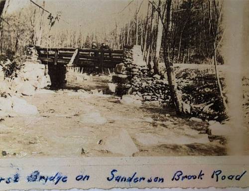
On February 23rd we hiked Griffin Brook Road to State Road to the washed out bridge over Sanderson Brook in the middle of Chester Blandford State Forest. What a great group to hike with! Everyone was well prepared for the snow/ice conditions and had a lot of fun and completed the entire hike. We did some wildlife tracking/identification and I gave some folklore/history of the trail. Hiking deep into the forest during winter conditions is beautiful but can sometimes be rough, thanks to whoever made the snowmobile trail for us the day before!


December 15th, 2018 Group hike at the Knightville Flood Plain in Huntington


Picture by Richard Chapman
December 14th 2019 we hiked Nobleview Outdoor Center in Russell to Pitcher Brook. After two feet of snowfall and 3 days of rain the week before the trail was spotty ice and snow, nothing we couldn’t handle with spikes, the rain stopped just long enough to complete our hike! Learn mpre about Nobleview http://www.nobleviewoutdoorcenter.org/noble-view-history.html


