This event has passed.

NINE self guided group hikes on May 22nd in Chester
May 22, 2021
Chester On Track is May 22nd!
We are offering NINE self guided hikes again this year to all of you in Chester in honor of COT, the events are all posted on facebook with trail info. Maps can be found for all locations on www.westernmasshilltownhikers.com. All six of us hike leaders, Liz, Lyle, Kim, Karen, Michele and Russ will be out and about all day live streaming at various locations all day!
Come experience Chester, Mass! We are super excited!
For more hike information email westernmasshilltownhikers@aol.com or call/text 413-302-0312. Follow us on Facebook, Instagram, Flickr, YouTube and Twitter. We also have a group on Meetup!
FOOD: Hungry? Call in your order at Carm’s Restaurant, 241 Route 20, Chester, Ma 01011. 413-354-1080 8am to 1pm www.carmsinchester.com
and Chester Common Table 4 to 9pm on Main Street. Also Pizza and grinders at the Blue Note on 29 Main Street (413) 354-6554 https://www.facebook.com/Classic-Pizza-Blue-Note-Cafe-116014375117344/
hashtag #westernmasshilltownhikers and #hikethehilltowns #visitchestermass #chesterma Post your photos with a hashtag! Post your hike photos on our Facebook group page! Events, maps and photos located at www.westernmasshilltownhikers.com Please keep our beautiful places clean and carry in and carry out.
1. Keystone Arch Bridges Trail (20+) Hike Chester Mass at the Keystone Arch Bridges Trail Self Guided | Facebook
GPS Location: 42.311910, -72.992649 trailhead parking limited to 10 cars, don’t park on the street you will get a ticket. There is 10 more spots available down the hill near the double arch. Additional parking at Chester Elementary School 1 mile down the hill.
Hike Rating: Moderate Approx. 5 miles total. Plan for four hours hike time.
PLEASE NOTE THIS HIKE IS ON YOUR OWN WITH NO HIKE LEADER

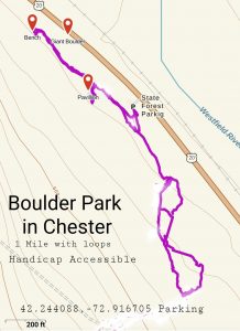
2. Boulder Park (20+) Hike Chester Mass At Boulder Park Self Guided | Facebook
GPS Location: 42.248407, -72.927933 On Route 20 in Chester, look for the sign and a giant boulder by the road. Large parking lot.
Hike Rating: Very easy. Approx. 2 miles total with many options. Plan for two hours hike time. This is a handicap accessible trail.
Hike around Boulder Park, there are many short trails with wonderful walls and bridges, this is more of a walk than a hike. Post your photos of your hike on our Facebook group page!
PLEASE NOTE THIS HIKE IS ON YOUR OWN WITH NO HIKE LEADER
Boulder Park in Chester on Route 20 #visitchestermass
In the 1920s, the National Park Service, under landscape architect Daniel Ray Hull, developed the “Park Rustic” style which emphasized the use of local materials and naturalistic design for new buildings and structures. The Park Rustic style was seen as a way to maintain the parks’ natural scenic qualities by carefully blending in new construction. During the Depression, the Civilian Conservation Corps spread the style throughout Massachusetts’s state parks, including here at Boulder Park between 1934 and 1936. The CCC developed the park as a day-use facility and used local stones to construct walls two pedestrian bridges, five fireplaces, a wellhead, the pavilion, and a system of stream conduits and culverts, The CCC also builtan earthen dam to create a swimming pond, as well as a rustic gazebo and bathhouse and laid out ski trails for winter use of the park #hikethehilltowns with the #westernmasshilltownhikers
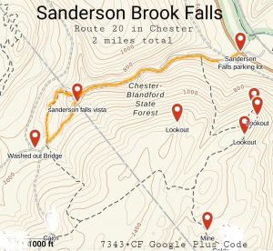
3. Sanderson Brook Falls (20+) Hike Chester Mass at Sanderson Brook Falls Self Guided | Facebook
GPS Location: 42.25618, -72.94677 Parking at Sanderson Brook Falls Lot
Hike Rating: Easy Approx. 3 miles total with options hike in to the waterfal and back Explore the Chester Blandford State Forest too!
PLEASE NOTE THIS HIKE IS ON YOUR OWN WITH NO HIKE LEADER
4. Goldmine Falls (20+) Hike Chester Mass at Goldmine Falls Self Guided | Facebook
GPS Location: 42.24782, -72.92470 parking on Route 20 pull off just after DCR headquarters, look for yellow road sign next to guardrail for trail entrance.
Hike Rating: Moderate Approx. 2 miles total with options
Roots, Rocks and an uphill climb
Roots, Rocks and an uphill climb
PLEASE NOTE THIS HIKE IS ON YOUR OWN WITH NO HIKE LEADER

5. H. Newman Marsh and Memorial Trail (20+) Hike Chester Mass at H Newman Marsh & Memorial Trail Self Guided | Facebook
GPS Location: 42.25618, -72.94677 Parking at Sanderson Brook Falls Lot
Hike Rating: Moderate climb up, easy around the top Approx. 4 miles total with options. Hike up the H Newman Marsh Trail, steep initial climb, cross the gorge then hike the Memorial Trai; loop around the top. This is a spoon loop trail. Rocks and roots and stone steps.
#hikethehilltowns
#hikethehilltowns
PLEASE NOTE THIS HIKE IS ON YOUR OWN WITH NO HIKE LEADER

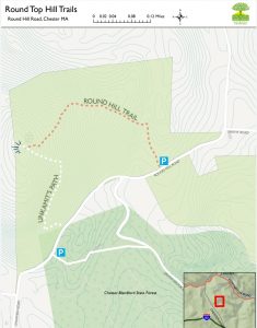
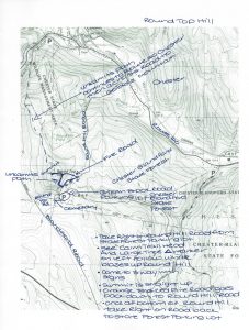
6. Round Top Hill (20+) Hike Chester Mass at Round Top Hill Self Guided | Facebook
GPS Location: 42.25145, -72.98442 Parking at Chester Blandford State Forest Lot off Round Hill Road 42.25095, -72.98643 at the Wright Memorial Cemetary on Round Hill Road. Trailhead at 42.252857 -72.98471 on Round Hill Road look for big tree on side of road with engraved triangle follow the white dot blazes up the mountain.
NOTE: Enter Round Hill Road from Blandford Road in Chester NOT from Route 20
Hike Rating: Difficult on the way up, Moderate sloping fire road on the way down Approx. 4 miles total. Plan for two hours hike time.
Hike up from Round Hill Road at the trailhead marked by an engraved triangle in a large tree along the white dot Unkamit’s Path to the vista look for signage guiding you! then down on the orange blazed fire road which is not as steep. This is a loop trail. Hike to the highest point in Hampden County! Find the three elevation markers at the top embedded in rocks. Find the Cache at the top and sign the book! This is a Hilltown Land Trust property. Post your photos of your hike on our Facebook group page!
PLEASE NOTE THIS HIKE IS ON YOUR OWN WITH NO HIKE LEADER
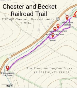
7. Chester Becket Railroad Trail (20+) Hike Chester Mass at Chester Becket Railroad Trail Self Guided | Facebook
GPS Location: 42.27937, -72.98827 Parking and Trailhead parking lot is on Hampden Street off Route 20 in Chester at the kiosk.
Hike Rating: Easy Approx. 2 miles total in and back. Experience the history of the old Chester Becket Railroad which once brought Granite from the Becket Quarry to the Boston Albany Railroad and the Town of Chester. See the Chester Walking Map on www.westernmasshilltownhikers.com
PLEASE NOTE THIS HIKE IS ON YOUR OWN WITH NO HIKE LEADER
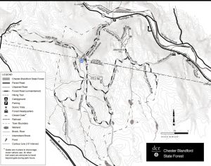
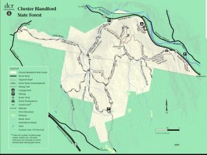
8. Chester Blandford State Forest (20+) Hike Chester Mass Chester Blandford St Forest Trails Self Guided | Facebook
GPS Location: 42.25618, -72.94677 Parking at Sanderson Brook Falls Lot
Hike Rating: Moderate Approx. 12 miles total of various trails. enjoy all the trails including Sanderson Brook Road, Dynamite Box Trail, Beulah Land Road, Observation Hill Road, CCC Ski Trail, Mica Mine Road, H Newman Marsh Trail
PLEASE NOTE THIS HIKE IS ON YOUR OWN WITH NO HIKE LEADER
#hikethehilltowns
Western Mass Hilltown Hikers invites you to hike all the trails in Chester Massachusetts for Virtual Chester On Track
Saturday May 22nd all day
Western Mass Hilltown Hikers invites you to hike all the trails in Chester Massachusetts for Virtual Chester On Track
Saturday May 22nd all day
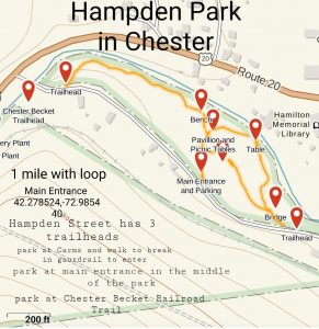
GPS Location: 42.278335, -72.984893 There is parking on Hampden Street, Look for the sign for the park. Hampden Street is off of Route 20
Hike Rating: Easy Approx. 1.5 miles total. This is Chester’s official Town Park and its beautiful, walk along Walker Brook on a flat trail. There are benches and picnic tables, get lunch at Carm’s and sit and relax after you explore!
PLEASE NOTE THIS HIKE IS ON YOUR OWN WITH NO HIKE LEADER.