
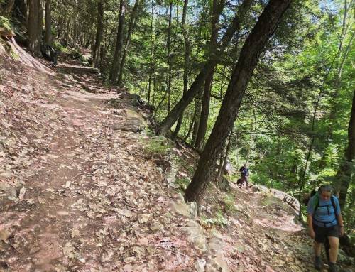
We set off to discover Alford Springs, two loop trails, each very different and a spur. High up on the New York border we found easy walking on old cart paths with ups and downs, the father loop gave us spectacular summit views, the mother loop was grassy, with wildflowers and views too! 6.6 miles total completing all trails here in 4 hours. Some more info from BNRC below, great job creating and preserving this pleasing trail!
The Mother Loop offers a more traditional hiking trail, under dense canopy and with a view to the east. Hikers can also explore an old foundation, and open field with apple trees.


The Saddle Trail begins by crossing a wet meadow and ascends the east slope of the Taconic Range on what might have been a driveway had BNRC’s supporters not conserved the property. From the would-be house site, there is a bench and a nice view of Tom Ball Mountain to the east. The trail utilizes a small saddle in the topography, winding through hemlock forest and past old stone walls and paddocks to connect to the Father Loop.
The trails are accessible year-round from trailheads with parking on Mountain Road and West Road. During every season but winter the Reserve can be accessed from a parking area at the end of Old Village Road.
Not many roads traverse this frontier, and the steep, heavily forested slopes don’t immediately attract the casual visitor. But you might be surprised if you venture that way by the user-friendly trails on the 899-acre BNRC property known as Alford Springs. The Alford Springs reserve lies on the eastern side of the Taconic Mountains, a chain that runs north-south along the Massachusetts-New York border. The Taconics were created 440 million years ago by a tectonic collision of the North American plate with a volcanic island chain. This land has been more hospitable to wildlife than human beings. There are cellar holes, remains of barns or outbuildings, and stone walls on the property, mostly abandoned in the 19th century. These structures represent the past agricultural history of the area. “Sheep fever” took hold of New England between 1810 and 1840 and resulted in 80% of forests being cleared for pasture or hayfield. 1837 was the peak year of sheep in Berkshire County with 136,000 sheep and 40,000 people. By 1900, more than half of the cleared land was becoming reforested. In the 1970’s Old Village Road was developed, and much of the current reserve was surveyed to become phase two of the subdivision. Luckily, the market slowed and BNRC, in partnership with Mass Wildlife, was able to acquire the land for conservation. From 2002 to 2018, BNRC has acquired parcels, piecing together the current reserve.
In 2016, a 25-acre forestry project on the Father Loop created early successional habitat along with excellent views of Mt. Greylock. Wild berries are everywhere and you may see sign of bear, deer and bobcat. What was once pastureland now has stands of a variety of trees, including white pine. A cold water brook and several intermittent streams tumble down from Alford Springs to feed AlfordBrook.
https://www.bnrc.org/trails-and-maps/top-berkshire-trails/alford-springs/ #alfordma

Leave a Reply