

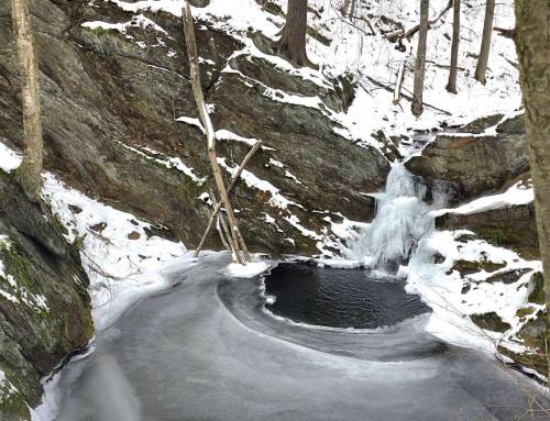
Race Brook Falls in Sheffield. Mt. Everett State Forest. You can hike up the entire waterfall to the start of Race Brook at the AT Race Brook shelter. Three trail options here, all show up on the GAIA app also on the State Forest map; shorter Lower Falls Trail easy in and back or the blue blazed trail to two different higher waterfall levels. We took the blue blazed Race Brook Falls trail from parking on Route 41. Trail is tremendously steep and rocky, took red blazed middle falls trail on the way down big mistake! even more steep. Definitely a tremendous hike only 1.77 miles to the falls but you will work for it. Took us 2 hours to get up and another 2 hours down, which was rocky and slippery. #hikethehilltowns with the #westernmasshilltownhikers


The one that is haunting me. Might go back today. Made it to lower falls easily. But I could not pick up the path to the 2 upper falls. Alltrails map seemed wrong in spots. Could not see markers past the point I ended up on the side of a steep mountain. Could almost hear one of them faintly. Was no problem getting out thanks to OpenGPX tracker. But any apps that you know will send me the right way? The map I used didn’t even show the path to the lower falls. I did that myself.
Mike, we use and recommend GAIA gps, it has never let us down!