
The Pontoosac Turnpike in North Becket.
During the first quarter of the 19th century, the need of a road between Springfield and Pittsfield was great, the Eighth Massachusetts first made the attempt, with construction difficulties through the town of Becket. The trouble was in the exceedingly rough and hilly pure of the country in that part of the Berkshires, which made construction expensive and maintenance difficult and costly, and for many years no route was known.
Smith’s History of Pittsfield tells us that, about 1818, it was discovered that good route could be followed through the “Pass of the Westfield,” along Westfield River to North Becket, and thence over Washington Mountain to Pittsfield, but people generally refused to believe it. On February 15, 1826, a charter for Pontoosac Turnpike Corporation was granted.
The route started from the southeast comer of Pittsfield and ran through the towns of Hinsdale, Middlefield, Washington, and Chester, following all the way through Middlefield on the northerly bank of the Westfield River and keeping close to the same river in Chester, until it reached the “road leading from Albany to Westfield, at a point near the tavern house of Colonel Henry.” located at the mouth of Walker Brook. The southerly terminus of the Pontoosac Turnpike was to be directly across the river from where the Chester Station of the Boston and Albany Railroad is now.
No records are known to exist of the money affairs of the Pontoosac, but it does not seem possible that it ever could have begun to pay. After nine vears the railroad came, and practically paralleled it, as well as connecting the same terminal points, so its life must have been short. Nothing has been found to show when it became free. In 1842 a petition was entered in Berkshire for the discontinuance of the turnpike and the laying out of the same as a county road, but it was dismissed. The section of road through the “Pass of the Westfield” has now disappeared from the map, only short stubs of roads showing at either end where corners were formerly made with other roads.
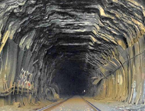
Travelers through the Berkshires over the Boston and Albany line follow close to the old road’s path for many miles. Passing through the bowl in which lies the village of Chester, the old Pontoosac can be seen on the opposite side of the little river, and running northerly from Chester’s main street, where it formerly terminated. A sandy country road now, it keeps along close to the railroad until the narrow semicircular valley prohibits the existence of two distinct routes of transportation. At the boundary line between Chester and Middlefield, where the steep slopes of Gobble Mountain run straight into the river, suggesting unfathomable depths, the old road ceases to exist, but traces may be seen, now on one side and again on the other, all the way to North Becket. Turnpikes of New England, Wood.
Give to YOUR LOCAL non-profit today! https://hilltownhikers.square.site/
Western Mass Hilltown Hikers
#hikethehilltownhistory Visit the Berkshires of Western Massachusetts Visit Massachusetts Explore Western Mass Massachusetts Office of Outdoor Recreation
#hikethehilltowns with the #westernmasshilltownhikers #discoverthehilltowns #hilltownhistory #flashhike #intheberkshires #nature #adventure #history #hiking #outdooradventures #visittheberkshires #mylocalMA #visitma #hilltownhikers #westernmass #hikingwithdogs
Visit our blog for all of our adventures! want to come along on these hikes? Become a member at www.hilltownhikers.com
Help conserve the Chester Granite Saw, our newest property! https://www.pledge.to/help-conserve-the-chester-granite-saw
Text HILLTOWNHIKERS to 707070 to donate.
www.hilltownhikers.com
You can mail your tax-deductible donation to Western Mass Hilltown Hikers, PO Box 3, Chester, MA 01011
Venmo @hilltownhikers
Stay informed – join our mailing list https://lp.constantcontactpages.com/…/hilltownhikeremail


Leave a Reply